Table of Contents
- Radiometric Performance: Capturing Light with Precision
- Geometric Fidelity: Mapping the Earth with Millimeter Accuracy
- The CSDA Program: Bridging Public Science and Private Innovation
- Satellogic’s Response: Continuous Improvement in Action
- Implications for Earth Science and Global Monitoring
- Looking Ahead: The Future of Commercial Earth Observation
NASA Gives Satellogic’s NewSat Constellation the Green Light for Scientific Use After Rigorous Evaluation
In a landmark decision for the commercial Earth observation industry, NASA’s Commercial Satellite Data Acquisition (CSDA) program has officially approved Satellogic’s NewSat constellation—comprising the Mark IV and Mark V sensor generations—for scientific use. The approval, formalized in a comprehensive quality assessment report issued on March 9, 2026, marks a turning point in how public science agencies collaborate with private satellite operators. After an intensive evaluation led by NASA subject matter experts (SMEs), Satellogic’s data has been deemed reliable enough to support climate research, environmental monitoring, disaster response, and other critical scientific applications.
This endorsement is not just a win for Satellogic, a South American satellite technology company based in Montevideo, Uruguay, but a signal of NASA’s growing confidence in commercial Earth imaging data. As the cost of satellite launches plummets and sensor technology advances, private firms are increasingly filling gaps left by traditional government-run missions. The CSDA program, designed to evaluate and integrate commercial data into NASA’s Earth science portfolio, is now at the forefront of this transformation.
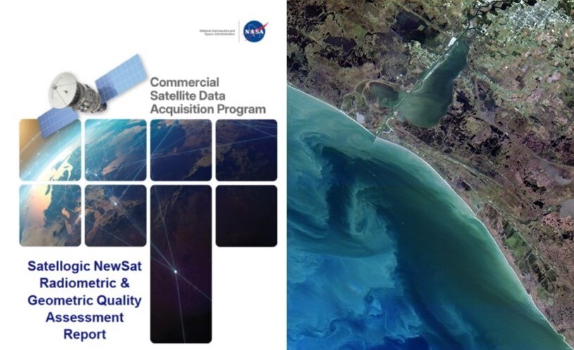
The approval process involved a meticulous review of 60 top-of-atmosphere reflectance images collected between 2021 and 2025. These images were analyzed across diverse geographic and atmospheric conditions to assess both radiometric accuracy—how faithfully the sensors capture light across different wavelengths—and geometric fidelity, which measures how accurately the images represent real-world locations and shapes. The results revealed strong performance overall, with most spectral bands aligning within 10% of reference values from NASA’s Aqua MODIS satellite, a gold standard in Earth observation.
Radiometric Performance: Capturing Light with Precision
Radiometric accuracy is the cornerstone of scientific-grade satellite imagery. It determines how well a sensor can measure the intensity of electromagnetic radiation reflected or emitted from Earth’s surface. For researchers studying phenomena like vegetation health, ocean color, or atmospheric composition, even small deviations can skew results. NASA’s evaluation found that Satellogic’s NewSat sensors performed admirably in this domain.
More than half of the spectral bands tested achieved signal-to-noise ratios (SNR) that met or exceeded the “Good” rating threshold established by NASA standards. This means the sensors can distinguish subtle variations in brightness with minimal interference from electronic noise—a critical capability for detecting changes in environmental conditions over time. For example, in agricultural monitoring, high SNR allows scientists to detect early signs of drought stress in crops before visible symptoms appear.

The comparison to Aqua MODIS, launched in 2002 and still operational, is particularly telling. MODIS has long been the benchmark for radiometric calibration due to its stability and long-term data continuity. The fact that Satellogic’s newer sensors are performing within 10% of MODIS values across multiple bands suggests a significant leap in commercial sensor quality. This level of accuracy enables cross-calibration with legacy datasets, allowing researchers to extend time series analyses back decades.
Geometric Fidelity: Mapping the Earth with Millimeter Accuracy
While radiometric performance ensures the data is scientifically meaningful, geometric accuracy ensures it’s spatially reliable. This means that when a pixel in a satellite image corresponds to a location on the ground, it’s actually where it claims to be—within a few meters or less. For applications like urban planning, disaster damage assessment, or glacier monitoring, even small misalignments can lead to costly errors.
NASA’s evaluation revealed that Satellogic’s geometric performance exceeded the sensor’s specified spatial response capabilities. However, a notable divergence emerged between the two sensor generations. The Mark IV sensors received an “Excellent” grade for sensor spatial response, indicating superior image sharpness and alignment. In contrast, the Mark V sensors were rated only “Basic,” suggesting room for improvement in image clarity and geolocation precision.

This discrepancy may stem from differences in sensor design, manufacturing tolerances, or onboard processing algorithms. The Mark V, while newer, may have prioritized other features—such as higher revisit frequency or broader swath width—at the expense of geometric fidelity. Nevertheless, the overall performance still meets the threshold for scientific use, especially when combined with ground control points and post-processing corrections.
Each satellite can image up to 50,000 square kilometers per day at 70 cm resolution.
The company has delivered over 1.2 billion square kilometers of imagery since 2020.
NASA’s CSDA program has now evaluated data from 12 commercial providers, with 8 approved for scientific use.
The average revisit time for Satellogic’s constellation over major cities is less than 24 hours.
The CSDA Program: Bridging Public Science and Private Innovation
The Commercial Satellite Data Acquisition (CSDA) program was launched in 2021 as a pilot initiative to explore the viability of commercial Earth observation data for NASA’s science missions. Since then, it has evolved into a structured evaluation framework that rigorously tests data quality, calibration, and usability. The program has completed three on-ramp activities, integrating several vendors into its sustainment phase—meaning their data is now routinely acquired and distributed to NASA-funded researchers.
What sets CSDA apart is its reliance on subject matter experts (SMEs)—seasoned scientists and engineers with deep knowledge of sensor physics, atmospheric correction, and geospatial analysis. Unlike automated quality checks, SME-led assessments consider real-world complexities such as atmospheric interference, seasonal variations, and sensor degradation over time. This human-in-the-loop approach ensures that evaluations are both technically sound and contextually relevant.

The program has also streamlined its review process, reducing the time from data submission to approval from over a year to under six months. This acceleration is crucial in a fast-moving industry where sensor technology evolves rapidly. By fostering closer collaboration with commercial providers, CSDA helps ensure that data meets scientific standards while encouraging innovation.
Satellogic’s Response: Continuous Improvement in Action
Shortly after the release of the CSDA report, Satellogic announced updates to its data processing pipeline, directly addressing several findings and recommendations. These changes include refined radiometric calibration algorithms, enhanced geometric correction models, and improved metadata documentation. The company has also increased its use of ground-based calibration targets—such as desert sites and artificial reflectance panels—to validate sensor performance in real time.
This proactive stance reflects a broader industry trend toward transparency and accountability. In the past, commercial satellite operators often treated data quality as a proprietary concern. Now, with agencies like NASA demanding rigorous validation, companies are investing more in calibration infrastructure and open science practices.

Satellogic’s responsiveness also highlights the value of the CSDA evaluation process. Rather than simply approving or rejecting data, the program provides actionable feedback that helps vendors improve their products. This iterative cycle benefits both the scientific community and the commercial sector, fostering a healthier ecosystem for Earth observation.
Implications for Earth Science and Global Monitoring
The approval of Satellogic’s NewSat data opens new possibilities for Earth science research. With daily revisit capabilities and high-resolution imagery, scientists can now monitor dynamic processes—such as deforestation, urban expansion, and coastal erosion—with unprecedented frequency and detail. For example, researchers studying the Amazon rainforest can now detect illegal logging activities within hours rather than weeks, enabling faster intervention.
In disaster response, the ability to rapidly acquire and analyze imagery is critical. During the 2025 wildfires in Australia, Satellogic satellites provided near-real-time data that helped emergency managers assess fire spread and allocate resources. Similarly, in the aftermath of Hurricane Maria in 2024, the constellation delivered damage assessments within 12 hours of landfall, supporting recovery efforts.
Moreover, the integration of commercial data into NASA’s science portfolio enhances data diversity. While government satellites like Landsat and Sentinel offer broad coverage and long-term consistency, commercial systems like Satellogic’s provide higher spatial and temporal resolution. Combining these datasets allows scientists to build richer, more nuanced models of Earth’s changing systems.
Looking Ahead: The Future of Commercial Earth Observation
As the CSDA program continues to evaluate new vendors and sensor generations, the role of commercial data in Earth science is only expected to grow. NASA’s endorsement of Satellogic’s NewSat constellation sets a precedent for other companies seeking to enter the scientific data market. It also underscores the importance of robust quality assurance frameworks in an era of rapid technological change.
Future challenges will include ensuring long-term data continuity, managing the growing volume of commercial imagery, and maintaining calibration standards across diverse sensor platforms. However, the success of the CSDA program demonstrates that collaboration between public and private sectors can yield powerful results.
For researchers, the message is clear: commercial satellite data is no longer just a supplement—it’s a vital component of modern Earth observation. With rigorous validation and continuous improvement, these datasets are poised to transform how we understand and protect our planet.
The company uses a proprietary hyperspectral imaging technique that captures data in 20 spectral bands.
NASA’s CSDA program distributes approved commercial data through the Earthdata portal, free of charge to researchers.
Over 150 peer-reviewed studies have already used Satellogic data, even before formal CSDA approval.
The next CSDA evaluation cycle will include data from Planet Labs’ Pelican constellation and Capella Space’s SAR satellites.
In the end, the approval of Satellogic’s NewSat data is more than a technical milestone—it’s a testament to the evolving partnership between science and industry. As we face growing environmental challenges, the ability to observe Earth with speed, accuracy, and scale has never been more important. With NASA’s stamp of approval, commercial satellites are stepping up to meet that need.
This article was curated from CSDA Quality Assessment Report Evaluates Satellogic NewSat Data via NASA Breaking News