In a mountainous region near the Iran–Pakistan border, satellite instruments have recorded a series of subtle changes in the Earth’s surface. These movements are neither dramatic nor visible to the eye, yet they are precise enough to prompt interest from geophysicists monitoring the area from afar.
The location lies far from urban centres and lacks dedicated instruments on the ground. Yet scientists have identified a pattern forming over several months, pointing to a shift that appears to originate from within the subsurface structure of a long-quiet volcano. Satellite data offers the only real-time insight into this evolving situation, capturing movements otherwise impossible to detect in such an isolated area.

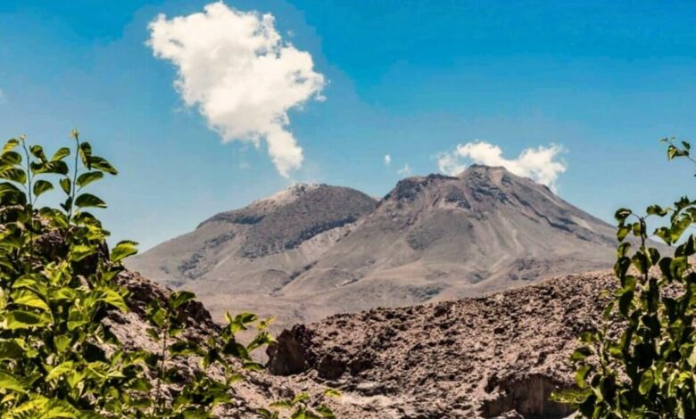
These developments concern Taftan, a remote stratovolcano in southeastern Iran, which until recently had shown no confirmed signs of activity for hundreds of thousands of years.
Satellite Observations Reveal Slow Uplift
Between July 2023 and May 2024, the summit area of Taftan rose by approximately 3.5 inches (9 centimetres). This uplift was detected using InSAR (Interferometric Synthetic Aperture Radar), a technique that uses satellite radar data to track subtle changes in the Earth’s surface. The analysis was conducted using data from the Sentinel-1 radar platform, part of the Copernicus Programme, operated by the European Space Agency (ESA).
This shift remained stable over the ten-month period, with no sign of reversal. A study published in Geophysical Research Letters in November 2025 modelled the source of the uplift at a depth of 490 to 630 metres beneath the summit. The deformation is consistent with pressure accumulating in a hydrothermal system—a network of hot fluids and gases circulating beneath the surface.

No evidence links the uplift to rainfall, seismic activity, or other external events. Researchers determined the cause is likely internal, driven by either gas accumulation in rock fractures or a small pulse of magma releasing volatiles into shallow subsurface layers.
Re-Evaluating Taftan’s Dormant Classification
Standing at 3,940 metres, Taftan is one of Iran’s tallest volcanoes and part of the Makran-Chagai arc, a tectonic zone shaped by the subduction of the Arabian Plate beneath the Eurasian Plate. Its summit vents emit sulphur-rich gas through fumaroles, which have remained active for decades. Despite this, no eruptive activity has been confirmed in recent geological time.
Historical reports refer to a period of intense gas emissions in 1902, with night-time glow visible from surrounding areas. A lava flow was also reported in 1993, though a detailed geological profile maintained by the Smithsonian Global Volcanism Program suggests it may have been a molten sulphur event rather than a volcanic eruption.
Dating of summit rock samples indicates the last confirmed magma-related activity occurred 700,000 to 800,000 years ago, based on zircon and K–Ar methods. While this classifies Taftan as a Pleistocene stratovolcano, volcanologists stress that long periods of dormancy are not unusual. Several volcanoes globally have remained inactive for millennia before exhibiting renewed surface changes.

The recent deformation places Taftan within a growing category of dormant but dynamic systems, where measurable ground changes may precede more pronounced activity—even without a visible eruption.
Lack of Ground Instruments Limits Situational Awareness
Taftan sits in a remote part of Sistan and Baluchestan Province, an arid, sparsely inhabited region with no permanent scientific monitoring infrastructure. The area lacks seismometers, GPS stations, and gas analyzers, leaving satellite data as the primary observational tool.
The Sentinel-1 satellite constellation, described by NASA Earthdata, plays a crucial role in filling these gaps. Its radar sensors detect surface motion through cloud cover and darkness. With a revisit cycle of around six days, the system enables the construction of detailed time series that show even slow geological changes over time.
The authors of the Geophysical Research Letters study recommend the creation of a local monitoring network, including ground-based instruments for measuring sulphur dioxide, carbon dioxide, and water vapour emissions. Such tools would help determine whether pressure beneath the volcano is stabilising or increasing.
Identifying the Risks of Shallow Gas Pressure
No eruptive activity has been observed, and scientists say the current uplift alone is not an indicator of imminent eruption. However, the movement is consistent with the type of pressure build-up that can lead to phreatic explosions—steam-driven events triggered when superheated water rapidly expands near the surface.
Phreatic eruptions typically involve no lava but can eject ash and gases over a short range. These events are unpredictable and occur with little or no warning. The risk is highest in systems where shallow gas pressure builds in confined areas and is suddenly released.
Taftan’s summit fumaroles remain active, and under certain atmospheric conditions, residents of nearby Khash, located 50 kilometres from the volcano, have reported sulphur odours carried by the wind. As noted in the article published by Earth.com, these emissions signal ongoing internal activity, even in the absence of visible changes at the surface.
Remote Volcano Wakes up After 700,000 Years of Complete Silence
Discover more from GTFyi.com
Subscribe to get the latest posts sent to your email.